One of the biggest developments in surveillance of all kinds, both military and civilian-focused, has been the advancement of hyperspectral imaging. This advanced technique of data gathering has revolutionised everything from covert and overt military missions to crop management, urban development and even underwater surveillance through the use of drones. Hyperspectral data has a wealth of functions in a wide range of theatres.
With the accelerated development of satellite technology over the last 20 years, combined with huge leaps forward in both software and user-friendly and portable hardware, hyperspectral imaging continues to play a key role in data gathering.
In this article, we’ll take a closer look at hyperspectral imaging, discussing what it is, how it works, and the applications it has. We’ll explore the difference between hyperspectral and multispectral, and explore some real-life uses of this technology. We’ll also introduce you to the FlySight hyperspectral advances that we as a company have made over the past few years, and where we see the technology developing in the future.
But first…
What is hyperspectral imaging?
Everything has its own unique wavelength, almost like a distinguishable signature. The wavelength determines what ‘colour’ we see when we look at something. So for example, a green plant will have a different spectral wavelength than a blue car or a red flower.
However, these make up only a fraction of the potential variants in different wavelengths, the majority of which cannot be distinguished by the human eye. The human perception of the spectrum is exceptionally limited (we can’t even see infrared naturally!), so we have always depended on technology to ‘fill in the gaps’ for us.
Multispectral imaging, the system that the majority of people will have heard of, allows us to evaluate an image in three to four colour spectrums (red, green, blue and near-infrared). While this enables us to see hundreds of colours, there is a vast amount of data that is still invisible using multispectral equipment.
Hyperspectral imaging uses a combination of algorithms and image processing technology to look way beyond that limited range and pick out targets against the general ‘background noise’ or clutter.
Hyperspectral cameras and hyperspectral imaging allow us to take that ability to see ‘colours’ and consequently shapes, from human to mechanical and natural, to the next level. A hyperspectral camera works in the same way as any other camera, by capturing light through a lens. However, it then splits it into its individual wavelengths, either through a diffraction grating or a prism.
Using a series of ‘beamsplitters’, early hyperspectral imaging created a series of “bins” in the four primary optical chains. These were then split into a series of secondary chains which resulted in a 16-channel spectral imaging tool that could cover a wavelength range of between 400 – 900nm.
The trouble was that this initial piece of equipment was huge, incredibly expensive, and very delicate. It had no ‘real-world’ application and was essentially a glorified laboratory spectral analyser. The trick was to get the accuracy, the robustness and, most importantly, the size, down to more manageable and practical levels.
Fortunately, today’s hyperspectral imaging technology meets those specific parameters, making it a far more versatile and practical addition to any onboard or land-based operations.
Technological advances
Through the development of cheap, high-quality diffraction gratings, combined with huge leaps forward in both processing ability and software technology, and the advancement of hyperspectral sensors that are far more sensitive than their predecessors, we can now apply this technology to a much broader range of uses.
Most hyperspectral imaging equipment is a combination of imaging optics, a narrow, graded slit, that all-important diffraction grating, and a 2D focal plane array detector, which is either a CMOS or CCD sensor. An image is projected through the slit, onto the diffraction grating, and then onto the focal plane array. Through a process of energizing the individual pixels at each XY coordinate, a 4D mapped image can be produced through an indexing process known as ‘pushbrooming’. Known variables can then be used to calibrate the image to create accurate data.
The big factor in all of this is the diffraction grating. Early 1.0 generation models used glass, which was not only incredibly fragile but also prone to flaws that could affect the data produced. Today, hyperspectral cameras and imaging systems use polymer gratings that are created from a calibrated ‘master’. This ensures that all diffraction gratings are exactly the same, ensuring that data from any device using this set-up will be accurate and reliable, as well as being testable against a baseline calibration number.
What is on offer
Speeding up the process
The second key advancement that has influenced the development of hyperspectral imaging systems has been the huge leaps forward in computer processing speeds. Because many of these systems are used in real-time, the data has to be processed and analysed incredibly quickly. Computers have become exponentially faster than they were 20 years ago, enabling even the most bloated of files to be analysed in real-time.
Connecting GPS, pushbroom data, known features and a variety of other information, modern hyperspectral imaging can operate at cycles in excess of 500fps. The result of this is that composite images can be formed, rather than simple linear ones, giving operators a much more detailed picture.
Eye in the sky – how satellites play a role in hyperspectral imaging
The massive explosion in the use of geosynchronous satellites for both military and civilian operations has enabled imaging to reach new and previously unimagined levels of clarity and detail. The link from operational bases to satellites works in fractions of a second, enabling them to deliver real-time data and help to ‘fine tune’ the process of analysing hyperspectral data more quickly and accurately. And thanks to the sheer number of satellites now in operation, a network covering the entire globe means that there is practically no place on Earth that cannot be seen by these eyes in the sky.
The data they produce, and the fact that many of them use hyperspectral cameras themselves, makes it simple to include massive amounts of information for even the most fluid of scenarios, such as weather prediction. Indeed, the use of satellite-based hyperspectral imaging may play an increasingly important role in the future as we are required to micromanage the local effects of climate change, for example.
Applications of hyperspectral imaging
While this sort of technology was initially developed for military use, the truth is that hyperspectral imaging has a wealth of applications in the civilian arena too.
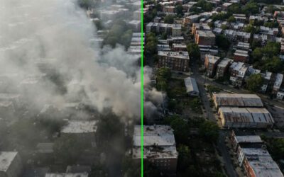
In a military theatre, hyperspectral imaging can be used to identify targets quickly and precisely. With a single pixel representing an area of around 1-2m², target acquisition is far more focused. Known parameters can be factored into the algorithm, narrowing down the possibilities and reducing the likelihood of a false positive putting the mission in jeopardy through an inaccurate target acquisition.
Overlapping both satellite-captured data and augmented reality into this process refines the operation even further, especially if, for example, one of the known variables is a particular vehicle or precise location address. It can be used to assess the damage path of a tornado or the impact of a hurricane over a larger area.
Hyperspectral cameras can be utilised in crime prevention too. For example, the wavelength of a particular plant such as opium poppies or cannabis can be isolated, allowing airborne operators to identify farms and direct ground forces to a precise location.
At the macro level, it can also have key uses in other theatres such as surveillance (including cross-border operations), search and rescue, and crop management. At the micro level, hyperspectral imaging has helped to advance medical analysis to new levels of accuracy, and continues to do so particularly in fields such as oncology and neurology.
Drone technology – custom-made for hyperspectral imaging cameras
Drone technology has spread from the military arena into civilian use – you can even buy drones in discount supermarkets these days! However, at a more professional level, drones are used by everyone from the police and law enforcement agencies to search and rescue units, land and forest management, and coastal units such as the coastguard and marine salvage operators. While multispectral cameras have been in use for some time, it has taken a while for hyperspectral cameras to become small and light enough to be used on drones.
Today, however, they are capable of fitting onto a drone, giving operators a far broader wavelength spectrum to analyse, increasing the amount of data they can retrieve and reacting more quickly to fluid situations. Because hyperspectral cameras can even penetrate through water, they are unhindered by marine barriers. While we referred to satellites as our eyes in the sky earlier, the truth is that, with the advent of lightweight and robust hyperspectral cameras, it is drones that are the future of aerial reconnaissance and data gathering, taking it down to the micro level and even more detailed rendering.
How FlySight is incorporating hyperspectral imaging into airborne operations
Because of the tie-in with satellite technology and the huge advances in both hardware and software development, hyperspectral data can now be utilised and gathered from airborne platforms. By creating fully customizable and ground-to-air integrated intelligence networks, FlySight’s OPENSIGHT technology can capture raw data and analyse it in real-time or post-mission. Hyperspectral data has a key role to play as part of an augmented, multi-platform PED for the processing, exploitation and dissemination of information.
The toolbox integrates a wide range of processes that are condensed down into a simple-to-use, handheld device. For the field of mission data analysis, OPENSIGHT represents a major advancement in both the accuracy and speed at which data can be obtained. Hyperspectral imaging plays an important role in this process, and is complemented by a full geo-exploitation toolbox that is intuitive and easy to operate in an airborne platform.
OPENSIGHT has been developed using the STANAG guidelines and rules, making it suitable for use anywhere in the world.
We continue to innovate and look for more ways of expanding the use of hyperspectral imaging and analysis, applying it to everything from military surveillance and search and rescue operations through to forestry and land management. If you would like to know more about our technology and how it could be utilised in your industry, browse our website and take a look at our video demonstrations of OPENSIGHT here. Or contact us in confidence via our online form.