To ensure that a mission goes to plan, analysis and data correlation is key. Mission planning is based on the gathering of accurate data. However, the best approach to mission management should incorporate technology that not only analyses and interprets historical data, but can also integrate real-time information too.
Military mission planning and technology used in police and civilian security operations now tend to overlap to a degree, utilising both onboard systems and satellite-based data-gathering technology.
In this article, we will explore up-and-coming technologies that can be used for mission planning. We will be looking at the technology itself, and how it helps with efficient mission planning and management, both in the theatre and back at a control centre.
The growth of AI
The almost exponential growth of AI within the field of mission management and in particular military planning has been remarkable. Capable of analysing and calculating mission strategies at a phenomenal rate, AI has proven to be exceptionally useful in all types of theatres.
However, a note of caution has to be added that mission planning cannot be based purely on AI alone. Indeed, AI, while impressive, has yet to fully realise its potential in this arena. It has to be used in conjunction with the human element, both in the air in the case of airborne units and back at mission control. The final decision to proceed with a mission has to be made by those in command, and not the technology that they use.
Having said that, the AI element has propagated huge advancements in the development of mission planning software and its implementation in the real world. While mission management still has to be a hybrid planning activity, there is no doubt that the incorporation of AI makes the process much easier and far more efficient.
AI’s future – joint problem-solving
Where AI really can assist going forward is in problem-solving and data analysis. The incredible ability of AI to not only process vast amounts of data very quickly and accurately, but also to learn and adapt its processing algorithms through experience makes it a valuable tool in military mission planning in particular. In the fluid theatre of battle or in surveillance operations, the ability to capture relevant data and then relay that quickly to operators in the air, the sea or on the ground is crucial.
AI needs parameters to work within, and these are set by the operators. Doing this ensures that AI captures the right or relevant data, picking it out carefully and cleanly from the background noise.
What is on offer
Hyperspectral Imaging
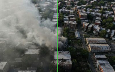
Hyperspectral imaging is not new and has been around for nearly a decade. However, this essential aspect of mission planning is now far advanced from the 1.0 versions of 2014. Now, this invaluable resource can differentiate between variations in vegetation, identify and isolate a camouflaged location or vehicle, or break down a broad-spectrum image into its individual wavelengths to uncover locations that may be hidden from the human eye at the minutest level of detail.
Hyperspectral imaging is now available not just for base operations but to operators in the field too, thanks to multi-layer software and handheld devices interconnected to a satellite network. It’s this joining of multiple technologies that makes hyperspectral imaging far more practical and useful than before, especially as the inclusion of satellite imaging gives it a real-time application.
New mission planning tools for satellites
Staying on the subject of off-world mission management tools for a moment, new advances are being made in the development of mission planning tools for satellites. New ways of integrating are exploring an entire network of satellites, both military, civilian and commercial, to plan and execute the correlation of data more effectively from various geosynchronous orbits.
The package includes Multi-Spectral Imagery (MSI), Radio Frequency (RF), Automatic Dependent Surveillance – Broadcast (ADS-B), Electro Optical (EO), Hyper-Spectral Imagery (HSI), Automatic Identification Systems (AIS), Synthetic Aperture Radar (SAR), weather forecasts, Full Motion Video (FMV), and potential Social (ex. Cell Phones) discoveries.
This multi-faceted approach to mission management software development gives multi-layered resolutions and greater detail. This can then be analysed and deep-dived for data to make subsequent missions more effective.
Web-based mission planning software
Mission planning software that’s web-based and easily accessed for both military and civilian uses is both cost-effective and user-friendly. Incorporating satellite data from multiple sources, it presents the data in an easy-to-read format that overlays data onto a real-time map. Used for more wide-ranging missions rather than close-quarters operations, it has the potential to help identify potential hotspots through the use of wide-area and border line slicing.
Aviation-based technology
While satellite-controlled spectral analysis can be used by ground and ocean-going operators, it’s the aviation industry that is leading the way in developing new mission management technology. Both civilian and military organisations are partnering to create software and technology that has applications in both military mission planning and non-combative roles such as search and rescue, land development, agriculture and even traffic management.
For example working with mission planning systems with more efficient touch-screen systems that incorporate augmented reality and geospatial software. The tablet-sized technology is both already familiar to the operator and intuitive to use, minimising training time and ensuring the product is operational across multiple platforms and in various theatres straight away.
Transferable to the general market
While many of these mission planning applications are primarily designed for military and law enforcement use, they are also transferable to the general market. Some of the new technology coming online (as well as much of that already in existence), such as hyperspectral analysis, has applications within agriculture. For example, it can be used to examine the health and development of crops and give the operator an instant snapshot of things such as water dispersal and ground saturation in real-time.
As climate change continues to alter our weather patterns, this kind of analysis will be vital to anticipate how crops respond to changing weather conditions. As a result, it could have a major influence on crop planting and even the development of new strains of crops to cope with climate change in the second half of the 21st century.
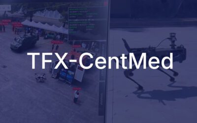
FlySight – creating mission-critical software for use in any theatre
Surveillance specialists FlySight are also pushing the boundaries of mission management with a plethora of mission planning technologies. However, where other producers of similar equipment and software tend to focus on one specific area, FlySight takes a more broad-brush approach, integrating multiple different platforms into a single Analyst Console.
What is the OPENSIGHT Analyst Console?
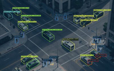
This turnkey solution has applications both in military mission planning and civilian and law enforcement scenarios. Delivering an all-in-one management system for airborne missions, it interconnects both the operator in the air and mission controllers back at base. Analyst Console consolidates several different FlySight technologies to help operators plan a mission and identify targets before the mission commences.
Once in the air, using handheld devices that include augmented reality and multiple layering, the console can assist in target acquisition within the parameters of the mission statement. This works equally well in both challenging urban and more rural environments, making it useful for both military and civilian or law enforcement operators.
Advanced technological data collection is important, but critical to any mission planning is the ability to utilise this information in real-time. Analyst Console does exactly that, as well as exporting the information gathered during the operation back to the operational base for deeper, more detailed examination later on.
Analyst Console never loses sight of the fact that a mission-critical decision requires the human touch. The object of Analyst Console is to be regarded as a tool, not a replacement, for the operator. While it provides the ability to incorporate multiple layers of augmented reality and data correlation within a single, real-time operation, the final analysis of the data it collects is carried out by a real person.
Operational in high-stress situations
One of the key components of any mission management system is that it needs to be easy to operate in high-stress situations. To this end, both FlySight and other developers within the field are working towards incorporating their software into familiar and user-friendly technology that is intuitive and simple to operate.
Not only does this multi-level system help operators (and in particular airborne units) operate more efficiently and without the need for additional expensive equipment, but it also assists ground-based managers in making mission-critical decisions in real time and ensuring the success of any mission.
Find out more about Analyst Console
OPENSIGHT Analyst Console is just one of several turnkey solutions provided by FlySight. Our expertise in the field of surveillance and information gathering has allowed us to create bespoke systems that can be tailored to specific needs, helping you and your team in mission management and planning both in the air and on the ground.
Our experts are here to work with you to create effective and productive analysis tools that improve your operational efficiency.
–> Get in touch today to find out more about FlySight’s mission management solutions.