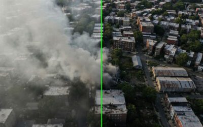
Using solutions that can integrate and merge information from heterogeneous sources and sensors is of paramount importance in maritime missions. Because of the vast areas covered, operators need to be able to identify craft immediately and without any inaccuracies. By using multisensor fusion that combines real-time video streaming with augmented reality, maritime identification can be made far more efficient.
Why is this important?
While surveillance, situation monitoring, or Search & Rescue on land are fraught with difficulties, the complex nature of maritime operations makes it even more imperative for systems to be both highly effective and accurate simultaneously. For air support vehicles, it’s essential to use their air time as efficiently as possible, primarily because of the limited range and air-time available. Therefore, the more information accessible to the operator in real-time, the better.
By combining live streaming video with overlaid augmented reality, it is possible to have ‘at-a-glance’ data that are instantly accessible. Georeferencing provides exact points of reference with all the information about the identified vessel available onscreen. This can include the vessel’s registration, exact latitude/longitude positioning, and heading.
In the event of an SOS, this information can be instantly relayed to the Search & Rescue teams, the Coastguard, and other organisations. This ability to information-share within seconds can make a massive difference to the chances of survival for maritime victims. Multisensor fusion also has numerous military applications, as well as law enforcement and international maritime control.
Identifying small targets
The critical component of systems such as OPENSIGHT-mc is its ability to integrate with current software and systems such as the Maritime Standard Automatic Identification System. This makes it particularly useful for operators carrying out coastal patrols, including those involved in identifying cross-border transgressions such as smuggling and trafficking.
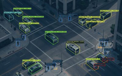
An automatic targeting display mode allows the operator to select a target (indicated by a green dot) and immediately access the ship or boat’s data. Hovering the mouse cursor over the target will enable the software to overlay this information onto the video, so swapping between screens is not necessary. As frames can be georeferenced in real-time, an accurate location and heading can be established for any vessel within seconds.
These information pop-ups can be customised, which is particularly useful for coastal patrol vessels that may be looking for specific suspect boats or ships.
Applications
A multisensor fusion system with geospatial situational awareness capabilities works with operators to enhance their ability to ‘read’ a situation. In a maritime context, this can ensure that coastal patrols are more effective and that search and rescue operations can be carried out with maximum efficiency.
All of the information that’s overlaid can be directly shared with other operators, allowing a more coordinated approach not just to SAR but to all maritime activities.
One of the key advantages of this type of AR setup is that it is incredibly intuitive and user-friendly. That enables operators to become familiar with the methodology used, the technological parameters, and the overall usability of the software with very little prior training. This kind of application has been purposefully designed to have a familiar feel, so the different layers are easily identified with a simple box-click system. For example, to multi-layer the augmented reality aspect onto the live video takes just one or two clicks of a cursor. The information is then overlaid instantly by the software, which is both Windows and Linux-compatible.
A future-proof system
The proliferation of boating and maritime leisure means that coastal patrols and Coastguard airborne operations are stretched to the limit. To ensure that every minute in the air is utilised as efficiently as possible, future-proofed systems such as OPENSIGHT-mc are becoming the norm. Augmented reality has repeatedly proven to be an effective way to maximise geospatial situational awareness and deliver accurate information to all users.
This ‘joined-up thinking’ approach makes better use of resources and delivers a better, safer system for those who rely on maritime organisations to protect them.