The core challenges of multi‑sensor integration in aviation fall into tightly linked categories, including synchronisation, redundancy management, compatibility, scalability, and certification. As aircraft systems become more sophisticated, integrating multiple sensors and control components becomes a highly complex engineering task with significant implications for flight safety, reliability, and regulatory compliance. Multi-sensor integration challenges don’t just affect aviation; they also concern any organisation that uses multi-sensor data in its systems, from autonomous vehicles to robotics.
While it offers many advantages, especially in aviation, it also presents significant challenges. In this article, we’ll examine those challenges and see how integrated sensor technologies and those involved in developing them are coming up with solutions. We’ll look at issues such as sensor compatibility, calibration, and data volume management, as well as environmental and operational factors.
We’ll explain why multi-sensor integration matters, introduce solutions such as FlySight’s innovative OPENSIGHT system, and show how integrated sensor technologies are tackling real-world challenges.
What is multi-sensor integration?
Multi‑sensor integration combines data from multiple sensors into a unified, coherent representation so that a system can perceive, understand, and act more accurately based on the information provided. It can provide a more comprehensive and robust understanding of the environment than relying on a single sensor in isolation.
Single sensors all have their own limitations. By combining data from multiple sensors (usually referred to as sensor data fusion), the limitations of individual sensors can be partly compensated for by complementary data from other sensors. For example, camera sensors are susceptible to poor lighting or foggy conditions and can be significantly affected by poor lighting, fog, haze, and other visibility conditions. Radar is generally less affected by conditions such as fog and darkness, although its spatial resolution is typically lower than that of optical sensors.
Integrating sensors into a single system lets each compensate for the others’ limitations, improving overall robustness and giving analytical algorithms a full spectrum of data to identify a target or define workable mission parameters. This is especially true in complex situations and environments, where increased reliability makes integrated sensor technology far more dependable than single-sensor systems.
Multi-sensor integration in aviation
The aviation industry has increasingly adopted multi-sensor integration as avionics and sensing technologies have evolved, not least because it dovetails so well with the physical constraints of a cramped cockpit. By combining data from multiple onboard and off-board sensors such as radar, IMUs, GPS, cameras, and environmental sensors, pilots and crew can obtain an integrated view of the aircraft and its surroundings, improving situational awareness, reducing pilot workload, and enhancing both mission safety and effectiveness.
Multi-sensor technology provides an accurate and reliable picture that can be further enhanced with Augmented Reality layers to create an enhanced 3D representation of the surroundings. The complexity and dynamic nature of aviation, especially for rotary platforms such as helicopters, make it essential to relay as much accurate information as possible to crews via multiple sensors. No single sensor can deliver the spectrum of detailed information that multi-sensor integration provides.
The main challenges faced with multi-sensor integration
As important as multi-sensor integration is to modern aviation, it still presents challenges. Imagine getting a dozen international experts in the same room to speak with a single voice, and you can see how data conflicts, language barriers, and timing turn what may be useful information into a cacophony of noise.
Multi-sensor integration faces the same challenges: getting sensors to communicate and share data without introducing conflicts, inconsistencies or excessive noise. The challenges are enormous, which is why multi-sensor technology has taken decades to evolve to the current level. Let’s take a closer look at the key challenges of multi-sensor integration.
- Sensor compatibility
Linking modern and legacy systems is one of the biggest challenges faced by multi-sensor technologies. Getting each sensor data stream to ‘sing from the same song sheet’ so that the information can be transposed to the operational console is the hardest part of the process. Factor in that new multi-sensor technology may not be physically compatible with some legacy operational systems, and you have the challenge of building pathways between the two.
The biggest challenge for aviation is the mix of analogue and digital architectures. Legacy systems may lack the interfaces, bandwidth or processing capabilities required to communicate effectively with modern sensors. For example, integrating fly-by-wire upgrades can be challenging where legacy systems and new controllers have different communication protocols, timing requirements and interface architectures.
Bus-level incompatibilities are also a key factor. Whereas a legacy system may use low-bandwidth ARINC 429 and other legacy interfaces, a bank of modern sensors may need high-speed Ethernet and complex networks to function correctly. The clash between two very different systems can contribute to latency spikes, data congestion, and complete failures because the systems cannot communicate properly. This also leads on to our second challenge, sensor calibration.
The solution – The most obvious way to overcome sensor incompatibility is to select compatible sensors carefully. While full standardisation is still a long way off, manufacturers and standards bodies continue to develop and adopt common interfaces and data standards to improve interoperability. Gradually replacing redundant systems also helps resolve conflicting sensor inputs.
- Sensor calibration
The core challenge of sensor calibration is that every sensor has its own biases, drifts, delays, and environmental sensitivities. Multi‑sensor systems depend on accurate calibration of individual sensors, as well as accurate alignment of their relative positions, orientations and timing.
In multi‑sensor platforms, particularly in aviation, this calibration is even harder because it must remain accurate despite vibration, environmental changes (such as air pressure and temperature), and long‑duration missions. Any process of multi-sensor integration has to take sensor calibration into account.
Sensor calibration helps ensure that sensor measurements are accurate and that their relative positions and characteristics are correctly understood. Monitoring and compensating for calibration drift can be important in systems exposed to changing operating conditions. Sensor performance can change during a mission as a result of vibration, temperature, pressure and other environmental factors, potentially affecting the quality of the integrated data.
The solution – Sensor calibration is not a one-time event; it is a continuous process to prevent calibration drift. For example, a rotorcraft such as a helicopter is subject to enormous stresses and forces. These can contribute to mechanical movement or vibration that may affect sensor alignment over time. Regular recalibration should be an integral part of the aircraft’s post-flight maintenance, while sensor calibration checks should be part of the pre-flight checks.
- Data fusion
Data fusion is the technique of combining multiple data streams from different sensors and presenting the cleaned-up information in a coherent, concise way, often in real time. Getting sensors to agree on formatting, timing, reliability, and ‘noise’ is the hard part. Any data fusion system must reconcile these differences while maintaining real-time operational parameters and ensuring the right information reaches the end user. Once again, it’s a question of compatibility, this time in the data streams produced by the sensors.
Data fusion requires all sensors participating in the fusion architecture to be aligned by three consistent parameters:
- Time – measurements need accurate temporal alignment
- Space – sensor positions, orientations and coordinate frames need to be aligned
- Semantics – data needs to be interpreted consistently across the system
If any of these are misaligned, data fusion is compromised, and the results are inconsistent. This is a major challenge, especially for multi-modal systems and those that use both onboard and off-board sensor data streams.
The solution: Data fusion solutions focus on choosing the right fusion architecture to create an environment where fusion can happen unimpeded. This requires aligning sensors in space and time, modelling uncertainty, and handling faults without interrupting the data flow. Using algorithms that match the sensor mix and, crucially, the mission environment is also paramount. Introducing AI algorithms can help to eliminate unnecessary noise, reducing the final data stream to a fused system of information that is relevant, trustworthy, and stable.
- Managing data volume
The sheer volume of data created by modern sensors is huge. For some legacy systems, it can be overwhelming, with the essential data (such as a target location) buried under a massive amount of ‘background noise’. Managing the data each sensor creates and integrating it with data from other sensors is a colossal task that requires powerful algorithms to control and maintain.
Another challenge in managing data volume is eliminating extraneous data to ensure only relevant information is transmitted to the control console. Hardware, particularly in aircraft, must meet strict safety criteria and protect sensitive information from cyber threats. Introducing hardware that can handle the volume of data while keeping it secure and compliant is a tough task.
The solution: Once again, AI plays a significant role in managing big data. Its ability to process huge amounts of data and reduce noise keeps data streams manageable. As machine-learning techniques improve, AI can help identify patterns, prioritise relevant information and streamline data processing.
- Environmental and operational factors
Every industry that uses multi-sensor integration technologies, from robotics and self-driving cars to aviation, must consider how environmental and operational factors affect the effectiveness of any component within an integrated sensor system. In aviation, extreme stress from vibration, altitude and pressure changes, temperature variations, and adverse weather can affect different elements of an integrated sensor network.
Self-driving cars must account for a wide range of variables in their operating environment to detect and respond appropriately to obstacles such as cyclists, motorcyclists and pedestrians. Robotics, especially those used in military theatres, have to take into consideration hazardous terrain, hostile forces, and sensory deprivation through poor visibility.
Multi-sensor integration is not isolated from environmental effects. Environmental factors directly influence it, and in particularly challenging situations such as disaster response or airborne maritime rescues, they can determine which sensor data remains sufficiently reliable for operational use.
The solution: Hardware challenges require hardware solutions, so sensors need to be protected as much as possible from poor weather, vibration, and extreme pressure changes. Operational challenges must be tackled one at a time, assessing the root cause and creating a bespoke fix. This could mean a unit with built-in anti-vibration padding, or configuring sensors and identification algorithms to identify specific obstacles without harming overall system performance.
The future look of multi-sensor integration
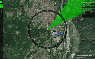
As demand for sensor fusion increases, multi-sensor integration technologies are quickly evolving to overcome the challenges faced by legacy systems. For example, the innovative FlySight OPENSIGHT Mission Suite uses data fusion and advanced sensors to improve real-time situational awareness in rotorcraft and UAV platforms.
This turnkey solution suite provides users with a customisable console that integrates powerful data fusion technology, giving operators relevant information on tap. By utilising onboard and off-board sensor data streams, OPENSIGHT uses video-processing algorithms for image enhancement, denoising, dehazing and, where supported, super-resolution processes.
Augmented Reality vector overlays in real time help create an enhanced 3D representation that can be exceptionally useful when more detailed information is required. All this and more creates an intuitive platform that can be integrated into some legacy systems, using technology that is already familiar to the operators.
You can find out more by accessing our database of video demonstrations and brochures on our Resources page. Or get in touch today to find out more about the OPENSIGHT Mission Suite for aviation.