From Raw Geodata to Mission-Ready Maps
Prepare. Style. Visualize.
Turn raster, elevation and vector data into optimized 3D-ready MBTILES — without coding, without complex workflows.
MAP CREATOR is the geospatial data preparation tool for the OPENSIGHT ecosystem, designed to transform raw datasets into high-performance map layers ready for real-time visualization in OPENSIGHT Mission Console and the OPENSIGHT 3D Engine.
Import your data. Define how it should look. Preview the result. Export.
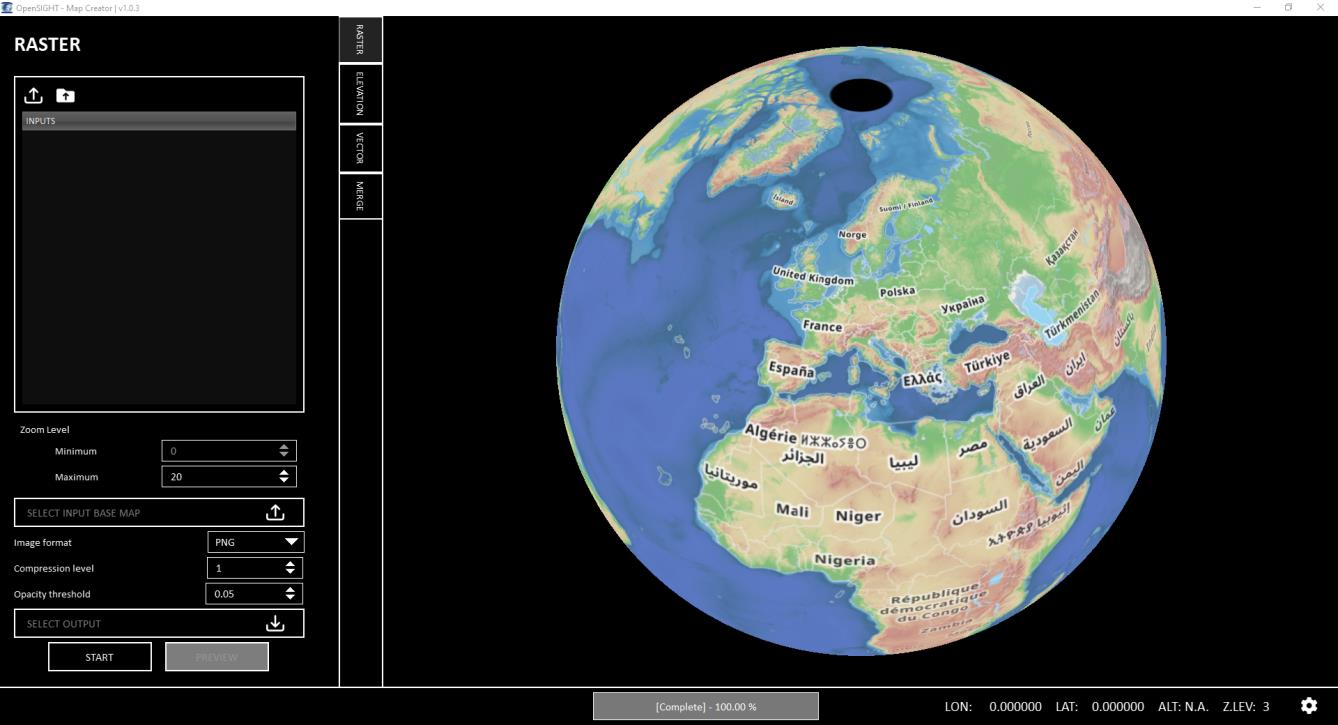
ONE TOOL. EVERY MAP.
Simplify the way you prepare geospatial data
Preparing geospatial data for real-time 3D visualization can involve multiple formats, processing tools and complex workflows.
MAP CREATOR brings the essential steps into one intuitive graphical environment.
IMPORT
Bring your existing geospatial data into MAP CREATOR.
Support for raster, elevation and vector datasets, including:
TIFF · JPG · PNG · ECW · CADRG · CIB · MrSID · DTED · SHP
STYLE
Control how your data appears in the final visualization.
Apply rules based on feature attributes and define Colors · Labels · Extrusion · Altitude · Elevation Offset
PREVIEW
See your map before you export it.
Use the integrated live preview to verify your data, styling and 3D representation throughout the workflow.
EXPORT
Generate optimized .mbtiles packages ready for visualization and offline use.
MERGE
Combine multiple datasets into a single map package — from base layers to overlays.
VISUALIZE
Load your prepared maps into the OPENSIGHT environment and bring your geospatial data directly into the operational workflow.
Your Data, Ready for 3D
MAP CREATOR is designed around the different types of data required to build rich 3D environments.
RASTER, Turn imagery into optimized map tiles. Transform imagery into optimized MBTILES.
Configure:
- Image compression
- Zoom levels
- Dataset coverage
ELEVATION, turn terrain data into high-accuracy elevation tiles. Generate single-band Int16 MBTILES from DT0 · DT1 · DT2
VECTOR, Transform vector data into 3D-ready map layers. Convert shapefiles into MVT-based MBTILES and define how features should behave in the 3D environment.
Create visualization rules for:
- Feature colors
- Labels
- 3D extrusion
- Altitude modes
- Elevation offsets
STYLE DATA. DON’T JUST DISPLAY IT.
Make your geospatial data work for the visualization.
With the Advanced Styling Engine, MAP CREATOR turns raw vector attributes into visual rules.
Define how individual features should look and behave based on their data.
Set fixed values or build attribute-driven rules for dynamic visualization.
MAP CREATOR provides live visual feedback throughout the preparation process.
COLOR – Define visual properties for your features.
LABELS – Display relevant information directly on the map.
EXTRUSION – Turn 2D vector features 3D objects.
ALTITUDE – Control how features are positioned within the 3D environment.
ELEVATION OFFSET – Fine-tune the relationship between vector data and terrain.
ATTRIBUTE-DRIVEN RULES – Let your data determine how it is visualized.
Merge data. Build the bigger picture
MBTILES Merge lets you combine multiple sources into a single, unified map package.
Bring together: BASE MAPS + IMAGERY + OVERLAYS + VECTOR DATA
Create seamless map packages for large-area and offline visualization, including environments where network connectivity is limited or unavailable.
READY FOR THE MISSION
MAP CREATOR is part of the OPENSIGHT ecosystem.
Prepared datasets can be integrated directly with OPENSIGHT Mission Console, connecting geospatial data preparation with mission planning, visualization and operational workflows.
Key Capabilities
| Capability | Description |
|---|---|
| Raster Tiling | Convert imagery into optimized MBTILES |
| Elevation Tiling | Generate Int16 elevation tiles from DTED |
| Vector Tiling | Convert shapefiles into MVT-based MBTILES |
| Smart Styling | Create attribute-driven visualization rules |
| 3D Extrusion | Turn vector features into 3D representations |
| Labels | Render dynamic feature labels |
| Altitude Modes | Define feature positioning within 3D environments |
| Live Preview | Validate visualization before export |
| MBTILES Merge | Combine datasets into unified map packages |
| Offline Maps | Prepare self-contained geospatial datasets |
| Mission Console | Direct integration with OPENSIGHT Mission Console system |
| No-Code Workflow | Complete preparation through a graphical interface |
Want to know more about OPENSIGHT?
Designed and developed to meet specific needs in any scenario, OPENSIGHT is a multi-platform PED (Processing, Exploitation and Dissemination) system created to provide the best support in decision making.
Contact us, our team is here to help!