One of the most critical components in Search and Rescue (SAR) operations isn’t the helicopter. It isn’t the ground crews or the command centre. It isn’t even the equipment. What really saves lives in an emergency is clear, precise, and accurate information. SAR communication is the lifeline of search and rescue operations.
Good communication enables time-critical decision-making and addresses multi-agency coordination challenges. In cases where people’s lives really do depend on the accuracy of information exchanges, technology is helping make SAR data links and communication even more accurate.
In this article, we’ll take an in-depth look at SAR data links as applied to helicopter search and rescue operations. We’ll outline the role of data link technology in SAR missions and how it works with helicopter search-and-rescue operations across various environments. We’ll look at the benefits for the crew and pilots, the type of data link technology particularly useful in aviation, and how it integrates with legacy systems and operational platforms. We’ll also examine the role of systems such as FlySight’s OPENSIGHT Mission Console and how it can serve as a linkable, highly effective SAR communication tool for modern SAR teams.
What are SAR data links?
SAR data links are the channels through which essential information is relayed between teams. These specialised systems transmit crucial data, such as survivor locations, mission updates, and sensor imagery. All of this is essential for coordinating accurate rescue missions that not only prioritise the safety and well-being of survivors but also those of the rescue teams themselves.
SAR communication systems are designed to share this mission-critical data in real or near-real time. They use a number of processes to do this, including line-of-sight radio, satellite communications, digital links on VHF and UHF, and specialist protocols.
They relay position and tracking data, such as a vehicle’s GPS position, enabling command centres to utilise their resources as efficiently and as effectively as possible. SAR data links can also assist in supporting managed search patterns and drift modelling for maritime rescues by collecting existing data, such as current charts.
The key takeaway from all of this is the absolute need for SAR systems to relay all relevant mission-critical information as quickly and, most importantly, as accurately as possible. Lives depend on its capability to achieve this on time, every time.
Sensor and imaging data – giving more visual input to a SAR mission
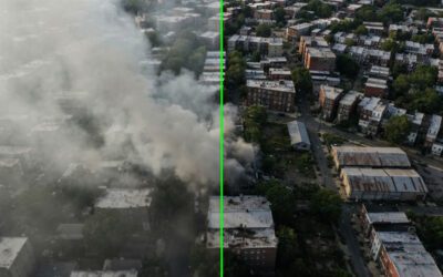
Helicopter units in a SAR context are the eyes of the rescue. Their position enables them to see far more than ground units and relay that information quickly and accurately so that on-the-ground teams can coordinate. Modern helicopters are equipped with a range of sensors and imaging equipment, providing information not just in the visible spectrum but also in the infrared and thermal bands. Night vision equipment punches through the dark, enabling the mission to continue after the light has faded, while 3D terrain visualisation using mapped and overlaid data can determine the land’s layout, even if a major incident such as a fire or earthquake has visually altered it.
Coupled with equipment such as EO camera feeds, anti-haze software that gives a clearer visual of the scene through smoke or fog, and a raft of AIS overlays, the helicopter is one of the most important and useful tools available to a SAR operation. Add to the mix the crew’s and pilot’s experience and expertise, and you have a truly essential part of any rescue mission.
The benefits of data link technology for air crews
The benefits of effective SAR communication are multi-layered, affecting both airborne and ground-based units.
- Data sharing – Sharing sensor, video, and audio data with ground crews is faster, easier, and more accurate. Integrated AI systems can also sift through ‘big data’ dumps and, with human oversight, help to reduce irrelevant background ‘noise’ to focus on essential data. This streamlines the data-sharing process, speeding up the deployment of new information that could make the difference between success and failure in a high-pressure SAR operation.
- Collaboration between emergency assets – SAR data links keep emergency teams connected and coordinated, making the very best use of resources, leading to faster rescues and a more efficient use of personnel and equipment. The information highway flows both ways, with ground crews also contributing to the collective data source, which in turn can determine where a helicopter or other aerial unit is located for maximum efficiency.
- Pairing air support teams with naval search crews – Maritime rescues present a whole new set of challenges, and once again, it’s the helicopter that can provide that all-important link in the chain. Their ‘birds-eye’ view and sensory observation of the rescue give them a more directional overview. In a location with minimal visual features, this is crucial, as it can allow an aerial unit to direct a maritime rescue team to a specific location using GPS coordinates.
At night, the sensory data a helicopter can gather using IR and night-vision technology can turn a seemingly hopeless situation into one where lives are saved.
Types of data link technology in aviation
A full arsenal of technology exists to assist aerial units during SAR operations. These provide clear and reliable connectivity between airborne operators and other SAR teams. The reason for having so many layers of SAR data links is to ensure that no information is lost due to failures, signal issues, or uncontrollable factors such as weather (including fog and poor visibility).
- Line-of-Sight – Line‑of‑sight data links, commonly referred to as LOS, are high‑bandwidth, low‑latency communication systems. These LOS systems communicate real-time data, such as video streams, telemetry, and other sensor data from on-board equipment, between units within the SAR operating team. This occurs as long as the antenna transmitting and receiving these data streams can effectively see each other.
Using direct radio-frequency paths in specific bandwidths, they are a key component thanks to their reliability and low latency. They are particularly effective in open or coastal environments, though terrain can limit performance in mountainous regions. LOS systems are further broken down into specialised SAR mission links, including EO/IR video data streams, AIS-integrated links for maritime operations, and digital microwave links for high-bandwidth video and sensor data transmission.
- SATCOM – The network of satellites orbiting the planet is an invaluable source of information, especially in large-scale rescue scenarios such as natural disasters, earthquakes, or tsunamis, or when the search is complicated by the destruction of known visual markers in an urban environment. SAR data links include this essential stream of information, providing rescue teams, including aerial units, with a vital real-time data source. Satellite communications provide reliable data links, while GNSS systems (such as GPS) provide positioning data, even in otherwise extreme or harsh conditions that may affect the quality of ground-based data streams.
- Tactical Data Links – Tactical Data Links (TDL) are standardised, secure digital communication systems that use military-grade protocols and, if necessary, encryption to convey mission data between airborne, ground, maritime, and command units. The fact that they use a standardised system means that cross-border rescue missions, where conflicting operating systems may otherwise result in a breakdown of communications, can take advantage of data streams delivered quickly and safely.
TDLs are particularly useful during complex rescues in hostile theatres. The secure nature of systems such as the NATO-standard Link 16 also helps reduce the risk of jamming or interception.
Integrating SAR data links
With the huge advances made in data technology, how can these obvious advantages be integrated into legacy systems? The reality is that it is increasingly achievable, thanks to mission consoles software such as FlySight’s OPENSIGHT. Data link technology requires compatible interfaces and integration pathways; modern helicopters, ground command centres, and mobile ground units already have those in place. This can result in effective collaborations between both operators and hardware units, such as UAVs and drones.
The information gathered from a huge range of sensors, including thermal imaging systems, GPS and maps, maritime tracking systems, and weather data, can be transmitted via SAR data links. Additional overlays can then be added via Augmented Reality console bolt-ons, giving the users a far more comprehensive overview of the situation. SAR data links can easily integrate with legacy systems, opening a new level of communication between platforms.
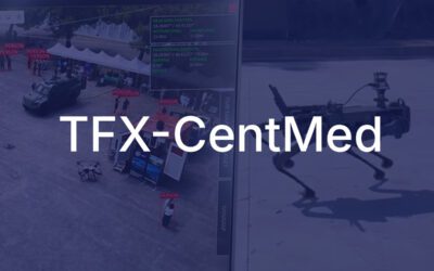
FlySight’s OPENSIGHT Mission Console
Effective helicopter SAR operations require a reliable and wide-ranging platform. The innovative FlySight OPENSIGHT Mission Console delivers exactly that, bringing a collection of mission-critical systems into one platform and enabling other platforms to connect to its onboard ecosystem. Combining real-time Augmented Reality and highly advanced video acquisition and enhancement programs, it significantly improves situational awareness for everyone involved in a SAR operation.
AR integrates real-time data with 3D mapping layers, while tools such as fog suppression enhance visibility in poor or foggy conditions. False colour enhances the visibility of essential details, while Super Resolution enhances the visibility of small details that can make all the difference in a SAR operation that involves locating a survivor in a complex environment.
You can find out more about OPENSIGHT’s Mission Console by browsing our Enhanced Reality System page or by reading our informative blog on Improving Helicopter Safety Through Advanced Avionics. You can also contact us directly to discuss your requirements and how OPENSIGHT can integrate with your existing parameters. Call us today for more information.