Location-based Augmented Reality is transforming the way military, law enforcement, and search and rescue airborne crews operate. Providing a wealth of information based on location rather than other marker-based systems, location-based AR utilises real-time location systems and overlays to offer operators an enhanced view of their environment and increased spatial awareness. Using this sophisticated technology in conjunction with other programs, it can help identify targets based on the user’s location.
In this article, we’ll take an in-depth look at location-based Augmented Reality and how it is being used in the military, law enforcement and SAR fields. Examining the technology behind it, we’ll also learn about the challenges and the potential future developments of location-based AR. We’ll also introduce the FlySight OPENSIGHT mission console, which incorporates this cutting-edge tech into an intuitive and practical solution for aerial platforms such as helicopters and, increasingly, drones.
What is location-based AR?
Location-based AR combines two levels of data: digital content, such as geospatial mapping, and the user’s real-time location. Sometimes referred to as geolocation Augmented Reality, it combines GPS, cellular data and other location-tracking systems to determine the user’s exact location and orientation.
It then overlays the digital data (for example, details on addresses in an urban landscape) and superimposes it onto the real-world view displayed on a console or device. Accurate and easy to update in real-time, location-based AR is a practical solution that delivers a wealth of information at the touch of a screen.
Other systems are available and can be used in other real-world applications. For example, marker-based AR uses markers to trigger and anchor high-contrast images such as QR codes. These are easily recognised by a device such as a smartphone, and can provide a direct link to a website, advertising campaign, or other source of data.
Similarly, projection-based AR, also referred to as spatial AR, projects digital content directly onto a surface. This can create an immersive experience and is used extensively in sectors such as healthcare, where its application in surgical guidance and teaching is advancing the skills of the next generation of surgeons. It’s also popular in retail, where it can be incorporated into an advertising campaign or product demonstration.
However useful these other types of AR prove to be in military, law enforcement, or SAR situations, especially involving airborne platforms such as helicopters, location-based Augmented Reality is far more practical and effective.
How does location-based AR work?
Location-based Augmented Reality utilises a series of ‘triggers’ to align the digital information layers with the physical location. We’ve already mentioned things such as GPS (which forms the foundation of location-based AR). However, this alone is not sufficient to establish a correlation between the physical position and AR technology, so more in-depth geospatial inputs must be included. These can be triggered by physical factors, such as landmarks, urban plans, including street maps, or the platform’s proximity to specific objects.
Once the location is firmly established (using a variety of sources to cross-reference the exact geospatial position), the augmented reality processor superimposes digital information onto the real-world view, such as a map on the operator’s device. This information can include graphics that orient according to the platform’s position in 3D, giving the operator far greater spatial awareness.
Because digital information is overlaid on top of real-world data, even if the landscape has been altered by a natural disaster such as an earthquake, location-based AR enables operators to pinpoint their exact position using various markers.
The key benefit of this particular type of geolocation Augmented Reality is that it is highly interactive and can be tailored to suit the exact parameters of the mission, whether that’s a search and rescue operation, a surveillance or intelligence gathering exercise, or reconnaissance over hostile terrain. The advent of miniaturisation also means that, combined with multi-spectral cameras and sensors, location-based Augmented Reality is now compact enough to fit onto unmanned drones as well as inside the console of a helicopter.
Uses for location-based AR
While marker-based Augmented Reality has seen growth in sectors such as entertainment and retail, location-based AR is more suited for use within law enforcement, the military, and search and rescue operations.
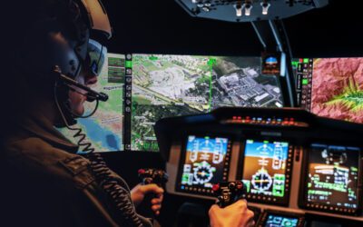
Systems such as FlySight’s OPENSIGHT Mission Console use location-based AR to enhance situational awareness and operational efficiency across different mission types. You can find out more here.
Law enforcement
Location-based AR is now a key element of airborne law enforcement. Its use enhances situational awareness, streamlines mission execution, and improves the safety of both ground units and air crews. It is particularly beneficial to particular areas of policing, with real-time tactical overlays aiding in target identification and acquisition, surveillance, and crowd control.
AR can provide detailed street and infrastructure mapping, overlaying a real-time map that can even provide individual information on separate residences in multi-occupancy buildings. This could be used when tracing a target back to a known address or likely location, allowing the air unit to guide ground units into a precise location effectively.
Dynamic target tracking, a feature available on FlySight’s OPENSIGHT Mission Console, enables airborne operators to track a single vehicle or multiple vehicles, indicating direction of travel, location, and identifying the target in a single display.
For crowd control, location-based AR can help units predict the dynamic flow of a crowd, factoring in pattern models that allow aerial units to track individual movements and identify potential crowd fluctuations on the ground.
The Military
Location-based AR is enhancing the way military helicopter airborne units operate through improved navigation, targeting, coordination with ground units and command centres, and operator situational awareness. The inclusion of AR is particularly relevant in hostile theatres, where every advantage is required to keep personnel and the aircraft itself safe.
Systems such as False Colour can enhance the visibility of mission-critical details, for example, the location of bunkers or suspected enemy hideouts, while preserving specifics that can identify the location at a later date. This can also indicate any changes that could signal enemy operations may have shifted.
Operations in hostile zones can be quickly obscured by hazy conditions such as fog or excessive smoke. Fog suppression or image dehazing can give airborne crews a far clearer visual of conditions on the ground, while using the cover of the fog as a defensive ‘cloak’ that can hide their exact location from enemy ground batteries.
Combined with infrared imaging and super-resolution, the ability of military air reconnaissance units to gather vital information is being enhanced on both manned and unmanned platforms.
Search and rescue
In a life-or-death situation, every second counts. Location-based AR provides SAR units with vital information that could make all the difference when carrying out search and rescue missions.
3D Terrain Visualisation AR overlays topographic maps and elevation data onto the pilot’s field of view. This provides pilots with significantly enhanced spatial awareness, improving low-altitude flight safety in mountainous or urban environments, particularly when those areas have been visually altered by a natural disaster, such as an earthquake or fire, and visual references have been destroyed.
AR overlays can also provide essential data on flood zones, fire perimeters, or disaster areas in real-time, aiding rapid response and safe navigation, as well as assisting in formulating effective search patterns to locate survivors.
The challenges of location-based AR
There are still challenges that need to be addressed when it comes to location-based AR. Location accuracy is essential – without that, location-based AR is pretty useless! So the integration of satellite and GPS positioning helps to alleviate that particular problem. The fact that information can be updated in real-time also helps to keep data current and accurate.
Battery use is a particular concern for drones, but as battery technology advances, this issue is becoming less significant. In manned aerial units, the problem is not so critical.
Data security and the sheer amount of data being produced and processed are other challenges, both of which are being tackled by linking systems such as OPENSIGHT. This allows data to be transferred between the console and mission control centres in any location; sensitive information is protected behind rigorous firewalls, yet still accessible to analysts whenever needed.
And while the software may be cutting-edge, what about the hardware? The fortunate aspect of systems like OPENSIGHT is that they can be integrated into existing systems with minimal hardware upgrades required. This also makes them far more user-friendly and intuitive, as operators are already familiar with the hardware, reducing any training needed to software familiarity only.
OPENSIGHT – Opening up AR in the Air
With a full complement of plug-ins and a variety of turnkey solutions, including mission consoles designed explicitly for aerial units, FlySight’s OPENSIGHT is leading the way in location-based Augmented Reality. You can find out more about its capabilities in a wide range of applications by downloading our brochure, or get in touch to discuss your needs and how OPENSIGHT can be tailored to fit your needs.