Avionics compliance is the foundation of aviation safety for passengers, crews, and those on the ground. It ensures that aircraft meet rigorous safety standards, from the smallest nut and bolt to the most complex of console systems. But as well as the hardware, avionics operators also need guidelines on where to fly, and that’s where compliance maps come in. These ensure that operators are aware of restrictions and issues through the use of constantly updated topographical and Enhanced Reality maps, processed through mission consoles such as FlySight’s OPENSIGHT.
In this article, we’ll take a more in-depth look at aviation compliance maps, explaining what they are and the different types used in aviation. We will examine how they differ from standard aviation navigational charts and why they’re used. We will also explore the latest generation of compliance maps and how they integrate into operational systems and consoles, and give an overview of the technology behind the maps that takes us into the latest AI and geospatial analytical tools available to the modern aviation operator.
A brief introduction to avionics compliance
Avionics compliance is a general term that refers to the adherence of aircraft systems to regulatory standards and requirements established by authorities. These authorities work together to ensure that standards are consistent across the globe, setting out minimum levels of compliance for systems such as communication, navigation, monitoring, and control systems. The key instigators of compliance are the FAA, the EASA, and the ICAO.
The necessity of exceptionally high and constantly monitored compliance regulations is obvious. The primary reason is, of course, safety. Avionics compliance ensures that, regardless of the aircraft type, including helicopters and now unmanned drones, the avionics systems it uses operate within strict tolerances, thereby ensuring the safety of passengers, crew, and those on the ground. Airworthiness certification is constantly revisited, ensuring that aircraft maintain these standards of compliance at all times. And because systems are standardised, communication and operational procedures are set to a consistently high level.
Where compliance maps come in is in the navigational aspect of avionics compliance. Just as on the ground, aircraft are required to adhere to flight routes, which can be affected by terrain, ‘no-fly’ zones, military areas, hostile zones, and so on. Compliance maps ensure that operators are fully aware of their location, which is why situational and locational awareness are crucial in preventing straying into prohibited zones or hazardous areas. Avionic compliance maps are the ‘roadmaps of the sky’, playing a fundamental role in the safety of aircraft in civilian, military, law enforcement and search and rescue operations.
Different types of aviation compliance maps
Avionics compliance maps cover a variety of different scenarios. From Airspace classification maps and No-Fly zones to terrain and obstacle data maps, environmental zones and restricted areas, the entire surface of the planet is covered by an intricate network of highly sophisticated digital maps. From take-off to landing, every element of an aircraft’s route is mapped out.
- Aerodrome Charts – Starting at the very beginning of the process, Aerodrome Charts provide a detailed layout of an airport, regardless of its size, including the location and orientation of runways and taxiways, the locations of emergency landing areas, and specified locations for helicopters and other rotor-bladed vehicles.
- Obstacle Charts (issued by the ICAO and categorised as Type A/B) – These give a visual representation of airspace classes from A to G, indicating flight corridors and restricted zones and are used in route planning and airspace compliance to avoid collisions.
- Airspace Classification maps – Globally applied, the ICAO Standard Airspace Classes are divided into seven categories labelled A to G, each with specific characteristics and varying levels of control indicating high or low traffic volume. A defines a High-Level controlled airspace, while G indicates uncontrolled airspace.
- FAA Sectional Charts – US-specific maps that include the topography of the region, demarcation of airspace boundaries, particularly around airports, and air corridors for commercial flight plans. These assist in VFR navigation and improve situational awareness for pilots.
- No-fly zones and restricted areas – These include everything from prohibited spaces, such as military bases and government buildings, to Restricted Airspace where access is granted with prior clearance, Danger Areas, and HIRTA Zones (High Intensity Radio Transmission Areas), where radio waves may interfere with the systems onboard an aircraft.
- Terrain and obstacle data maps – These are relatively self-explanatory and provide operators with detailed maps of locations, including urban layouts where obstacles such as power lines and high buildings could be a hazard to helicopters. These maps can also include information on Environmental Zones that are noise-sensitive or home to rare or endangered wildlife.
- Precision Approach Terrain Charts (PATC) – These charts show detailed information on terrain features, particularly in areas surrounding landing and mountainous sites, enabling pilots to execute precision approaches. This type of avionics compliance map ties in with instrument approach safety, making it particularly important for mission console setups.
Pilots also need to be aware of and familiar with communication and navigation requirements, as well as company and government regulations.
How do aviation compliance maps differ from standard aviation navigational charts?
Standard Aviation Navigational Charts are designed primarily for flight navigation and situational awareness, including topographical information and airways and routes. Aviation compliance maps focus on regulatory and operational constraints, and may also include temporary information that is regularly updated. These help ensure that flights adhere to national and international legal and safety requirements.
Using these maps offers several benefits, including ensuring that operators (both civilian and military) comply with regulatory requirements and avoid costly violations of FAA/EASA rules. They can help prevent operators from accidentally straying into restricted or hazardous airspace, as well as provide a far greater level of situational awareness in challenging areas, such as urban landscapes. All of this helps to ensure the safety of the platform, as well as the crew, and can also play a key role in mission and flight planning efficiency.
As systems become more integrated, these compliance maps are interconnected with real-time onboard avionics systems, providing the crew with immediate access to vital information. This leads to a far more effective risk mitigation that can help operators avoid legal penalties and minimise reputational damage for ingressions into prohibited airspace, for example.
Beyond the legalities, it’s also crucial for avionics operators to have a holistic understanding of all compliance maps. This is most easily done not only on the ground, but also in the air, using the latest generation of Augmented Reality consoles and mission systems, which integrate this information into existing topographical and standard aviation navigational charts. It’s an extra layer of data that can help define a mission’s parameters and ensure a more effective use of both equipment and personnel without risking the safety of the aircraft.
Avionic Compliance Maps and Mission Systems
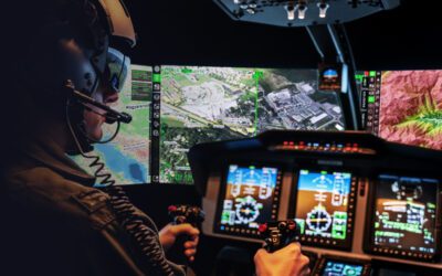
Avionic compliance maps and advanced mission systems, such as FlySight’s OPENSIGHT mission console, can be easily integrated. The opportunity to connect in real-time means that relevant data is instantly available for crews. This, in turn, creates a more effective working platform with enhanced interoperability. The connection between aerial units and command centres can also enable mission commanders to ensure aircraft don’t deviate from the compliance requirements. Enhanced reality elements enable maps to be overlaid on top of real-time imaging, giving operators a ‘three-dimensional’ overview of their terrain, including any restrictions such as No-Fly zones and hazardous airspace.
The technology behind compliance maps is constantly evolving. With real-time data feeds continuously updated, including NOTAMs, TFRs and AIP data, and dynamic updates via the Cloud, operators can ensure that their mission parameters, as well as the aircraft’s safety compliance requirements, are all met.
Due to the importance of compliance maps, they have been designed to integrate seamlessly with both new and existing systems, including EFB, FMS, and ADS-B systems, with no interruption to operational procedures. Regardless of where you operate and the type of vehicle you use, the ability of the technology to integrate with systems that operators are already familiar with makes them easier to work with and, in turn, easier to ensure full compliance, even during complex or hazardous missions.
With the inclusion of AI and geospatial analytics, today’s aerial platforms are not only fully compliant, but they also maintain uninterrupted operational effectiveness for both aircraft and crew.
OPENSIGHT’s Mission Console – a compliant option
To maximise the wealth of information available to air crews, FlySight’s OPENSIGHT offers the ideal platform for integration with compliance map systems. Fully integrated and using the latest generation of Enhanced Reality technology, OPENSIGHT can overlay both navigational and compliance maps to create a far more comprehensive operating system. The real advantage of a console such as OPENSIGHT is the interoperability between the onboard system and external inputs such as data from the sensors or information relayed directly from the command centre.
Adding key features such as Automatic Target Recognition and dehazing technology, which can provide operators with a clear field of vision even when the view is obscured by haze, fog, or smoke, also enables compliance maps to be adhered to. This is particularly important around No-Fly zones or hazardous areas, and helps to ensure the safety of the vehicle and crew even in challenging conditions.
You can find out more about OPENSIGHT by browsing our brochures and videos. Or get in touch and find out more about the OPENSIGHT Mission System and its avionics compliance map capabilities.